Death Valley is about 3 hours from Las Vegas, north on route 95, then south on 373 and west on 190.
 The first point of interest after entering the park is Dante's View, which offers a beautiful panoramic view over the southern part of the valley and the salt lake.
 Further along is Zabriskie Point, home to very interesting rock formation - actually, the whole valley is home to very interesting rock formations: besides the rock formations, the sand and the salt there is very little. Each corner of the valley is different though, I would never have thought that "rock formations" could be so very different before I went to the Southwest.
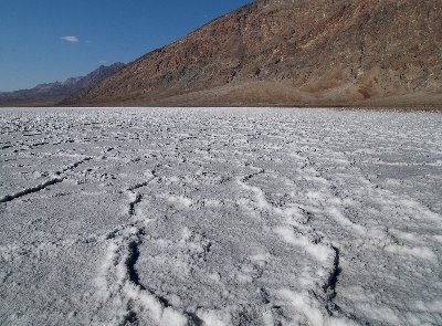 Shortly after Zabriskie Point you'll reach route 178; turn left and follow the road until Badwater; this is one of the spots from which you can access the salt lake without too much effort. Especially in the spring and summer months, Death Valley is extremely hot, and even short hikes can be dangerous, so don't underestimate even the shortest walk. People actually die in Death Valley fairly often.It's easy to underestimate the heat after you've been driving around for hours in a comfortably air-conditioned vehicle.
 Walking on the salt lake is like walking on April snow: the color and texture of the salt feel like snow, and in certain places your foot may break the surface and sink in a puddle of water. The water is coming from an underground system that, amazingly, even after thousands of years of desertification of the area, is still providing water. The salt lake is the lowest point in the continental US, if I recall correctly, some 282 feet (86 meters) below sea level. A sign halfway up the mountain marks sea level. Very impressive. It makes you want to imagine what it would look like here if there was water up to that level.
 Back north on 178, there are at least 3 turnoffs worth mentioning.
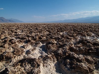
The first is the Devil's Golf Course. It has been thus named because, if it were a golf course, it would be the most difficult one in the world. I don't doubt that, but it also would be the most difficult basketball court, or baseball field, or soccer field... I don't know why they went for the golf course. Anyway, it's an apparently interminable field of dirt and salt lumps. Very strange. In retrospect, I think it would be a good subject for a view camera, with the front tilted down and the back tilted backwards, to increase the proportions of the lumps. Unfortunately I didn't have my view camera yet. Maybe next time - the place is certainly worth a second visit.
 The next turnoff is Artist's Drive; it is so named because of the pictoresque colors of the rocks and mountains; the highlight of the drive is the Painter's Palette, a group of orange, red, green, blue and white rocks. However, even more than the colored rocks, I found interesting the small colorful flowers and bushes that somehow manage to grow in this inhospitable environment. Purple, green, yellow, white, they are a sight in themselves.
 The third turnoff is salt creek; how much of the creek you'll be able to see depends on the time of year, but it's a very amazing view: in the middle of the desert, rocks, sand and salt, there is a small creek surrounded by lush (relatively speaking) vegetation. Many millenia ago, the creek used to be full of fresh water; now the water is salty, and one species of fresh water fish, having little choice, adapted to the salt in the water. This species (Cyprinodon Salinus, or pupfish) exists only in this creek. You should be able to see quite a few of the little fishes. The Park has built a wooden boardwalk along the creek, so that the delicate environment is not spoiled by the tourists.
 Back on route 190 in direction west, just before Stovepipe Wells, you'll see on the right the famous Death Valley dunes. You can park the car on the side of the road and walk to the dunes. The best time to do this is just before sundown: the heat is not as bad and the light is fantastic on the dunes. It took me about 2 hours to get to the tallest dune, walk around taking pictures, and come back to the road. If you attempt the hike, don't forget to bring lots of water: I brought about a gallon, drank all of it, and at the end I was dangerously close to dehydration. At dinner I drank a glass of water after the other, but I think the pictures were worth it.
 We stayed at a motel in Stovepipe Wells; very nice place, with a view over the desert (see picture on the left), a cool saloon where you can enjoy a cold beer, and even a small swimming pool. At night I played with some long-exposure pictures. As you can see from the star trails, the exposure was a couple of minutes long.
At the north end of the valley the main points of interest are Scotty's Castle and the Racetrack. The latter is well worth a photographic visit, but unfortunately our SUV had defective shocks and we weren't able to make it all the way to the end of the 30 mile long dirt road. If you attempt to get there, make sure that you have a good 4WD vehicle and plenty of time - the going is very slow.
 We didn't find Scotty's Castle particularly interesting, so we didn't take the guided tour, and instead headed back towards Beatty; we wanted to see the ghost town Rhyolite; it used to be a prosperous mining town at the turn of the last century, with even its own casino, but now it's just an agglomerate of empty shells of buildings.
From Beatty it's about another 2 hours to get back to Las Vegas.
The park is actually rather large; we didn't make it to the western part, and we skipped all of the canyon hikes. These may be more interesting than the things I wrote about, so make sure to find out about the other points of interest before you go.

No comments:
Post a Comment