Showing posts with label Travel. Show all posts

Saturday, October 27, 2007

Fall colors in Maine

Two weeks ago I was again in Maine, and it was pretty much peak time for the famous New England foliage colors. I was working, so there was very precious little time to take pictures, only in the morning and at dusk, but those are usually the best times anyway.

A friend was nice enough to take me on a long and strenuous hike up Borestone Mountain at about 6 am in below-freezing temperature and strong winds. I somehow managed to get on top, and the view was well worth the excruciating expedition:


The view from the top was fantastic, but also on the way up and down there were a few nice scenes, like this boat on one of the ponds along the trail, and, of course, lots of colorful trees...


I took the remaining pictures (the one on top and the one here on the left) when the sun was already very low and the air hazy, so it was hard to strike a balance between the darkening trees and the sky still bright with diffused light. The first picture required some work in Lightroom (some fill light, exposure and contrast adjustment, and negative vignetting correction) but I believe that the result is quite nice.


The last picture is the first I took; nothing special, I just stopped the car on the side of the road on my way up to the central part of the state, but it shows the nice scenary that you can find pretty much anywhere in Maine, especially in the fall.

Glacier National Park (Montana)

It's time to catch up with the posts here.

Back in July we went to Glacier National Park, in Montana. The weather was very good, clear , hot and hazy - this is not a good combination for photography. Unfortunately even at sunrise and sunset the light was very bland and meaningless.

Anyway, first things first: the mandatory picture of the island on St. Mary's lake. This is the best known view in the park and everybody takes a picture of it, so here we go:

The park covers a vast mountaneous range that was shaped in valleys and lakes by glaciers; many of these glaciers are still there today, even though they are dwindling in number and size very quickly. They estimate that within 30 years there will be no more glaciers left, but they assure us that the park will not change its name.


The mountains are not as impressive as I had anticipated, but the lakes are all very nice.
The first here on the left is Hidden Lake; it can be reached with a fairly long hike from Logan Pass, the highest point of the Going To The Sun Road. On the way, even in the summer, you will find a lot of snow and some mountain goats enjoying the cooler breeze in the altitude.


The Going To The Sun Road crosses the park in the east-west direction and gives you access to St. Mary's Lake and Lake McDonald (both here on the right). The road has a lot of traffic in the summer, but if you take the time to do some hiking you will find a lot of very nice, quiet and secluded places to explore.

I took the same picture of Lake McDonald with my large format camera, but the result was sort of disappointing. The light was just not right.

Less disappointing was the wildlife: besides the mountain goats, we also had a chilling encounter with a very aggressive, large and dangerous snake (I wasn't able to take a picture of it because I was busy running for my life, but I assure you that it was a very dangerous species).

Outside the park, in a wilderness preservation area south of Flathead Lake, we also found several bisons, a very aggressive, large and dangerous greezly bear (hmm... maybe not) feasting on top of a tree, and an antilope that didn't have any intention of letting us continue on our way.

Saturday, July 21, 2007

Seattle, WA, northern Idaho and Western MT

Last week we went for a few days to Glacier National Park; I'll post some pictures about it in the next few days, but for now I'll stick to the first part of our trip: Seattle, Washington state, northern Idaho and western Montana. Seattle is pretty far from Glacier NP, but direct flights into Montana on short notice are extremely expensive, so we had to do it this way.

It turned out to be a very good idea, because the city is very interesting, and so is the drive through Washington state, Idaho and the mountains of western Montana.

I took the first picture (below) by the ocean (actually Puget Sound) in Seattle; I didn't do any post-processing: the sky is as it was, and the street lamps are green because of the way the camera sees (I think) hot mercury vapors. Overall the effect is rather interesting.


The second picture is a lucky shot of some wild horses happily running on the crest of a hill near the Columbia river in Washington state. I just accentuated a bit the contrast of the thunderstorm clouds.


The third picture is an abandoned barn in Montana, along route 28, near the aptly named "Rattlesnake Gulch Road". I didn't see any rattlesnakes, but I bet there are many. This really is cowboy country!


Well, since you read this far, I'll let you in on a secret: the "wild horses" are not a lucky shot: they are steel sculptures that have been placed on top of the hill as a "Wild Horse Monument". They can be seen from a rest area just off I-90.

Monday, January 01, 2007

Tuscany, part 4: The Day-to-day Life

For the last part of this series on Tuscany, I wanted to show some nice (I think) pictures that show a little of how the people who are there every day live.

A pub in the main square of Lucca.


A bicycle parked outside a house in the center of Lucca.


A grocery store window in Lucca, displaying bread, focaccia, olives, salami, lard, prosciutto, and more.


A busy street in Florence, behind the majestic dome of the cathedral.


An unmarked police car in Florence (I know it's just a picture of a car, but I love that car! It's an Alfa Romeo 159, for those of you who may care).


A bus stop in Florence.


Clothes hung to dry in Siena.

Tuscany, part 3: The Art (Random Moments)

In Tuscany you can find enough Renaissance art to last you for a lifetime, in every town, at every streetcorner, and for a lot of it you can find plenty of information on the net. So even though I did take pictures of all the "mandatory" (really famous) stuff, I'll post only some random details that I shot here and there, in no particular order. Some of these, you may have never seen before.


Tuscany, part 2: The Chianti Valley

The Chianti Valley extends between Florence and Siena. It is the home of the famous Chianti vineyards; here is one of them:


You can drive from Florence to Siena in a couple of hours; the scenery is fantastic, and you can stop in any of the few small towns on the way for a think and juicy Fiorentina steak in one of the local trattorias. Here are a house in a typical small town, and an abandoned farmhouse (I don't think it will stay abandoned for long though - it looks like it could become a very nice B&B, or agriturismo).

Tuscany, part 1: Etruscan Tombs

Last summer we went to Italy for a few weeks. I finally have some time to post about that trip, but there is a lot to tell, so I'll do it in installments. Here is the first one.

Everybody knows about Tuscany: the rolling hills, the wine, the food, and so on. One of the less known things is that the region was home to the Etruscans, a mysterious people that thrived before the birth of Rome and that the Romans "absorbed" early on in their expansion, leaving little trace of their civilization. What is left are mostly underground tombs, scattered around the countryside.

You may be driving on a narrow winding road, when you may see a small sign directing you to a tomb in the middle of the woods, in a field, or in an olive orchard. Usually there is just a sign explaining when and how it was found, how old it is, and the little that is known about it. No tour guides on site, no admission ticket and no gift shop.


This is where we were walking to reach a tomb dating back from around the 3rd century before Christ.

Obviously the artifacts have long been removed and placed in museums or sold on the black art market, but the tombs themselves are fascinating, especially when you stop and realize that they are well over 2,000 years old.

These are the steps that lead down to one of the tombs.
Most of these tombs were built several feet underground, and you can access them only through these very steep and narrow stairs. It's kind of scary going down, because your eyes haven't adjusted from the bright summer day outside to the damp and mysterious darkness inside, and you don't quite know what to expect...

Here you can see the ledge where the dead were placed. The tomb is round, with a low vaulted ceiling and a pillar in the middle. The ledge runs around the perimeter of the tomb like a bench.

For more information about the Etruscans, refer to this very informative website: The Misterious Etruscans.

Sunday, September 10, 2006

The Photo-Travel Map

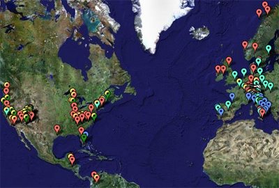
I made this website using the Google Maps API:


It's a satellite image of the Earth, where I superimposed markers that show (most of) the place that I have visited. When you click on a marker, a baloon pops up, with the description of the site and, in some cases, a small picture.

The map is a regular Google map, so you can navigate, zoom in and out, and explore.

At this time there are almost 200 markers, so it will take a few seconds to load (if you have high-speed internet - otherwise longer); please be patient. I will add more markers and pictures as I travel to new places.

If you want to make your own photo-travel-map, look at this tutorial.